 Secure Payment
 Free shipping on orders over €60 (UE)
 Financing on orders +60 €
 Hassle-free returns
Business solutions
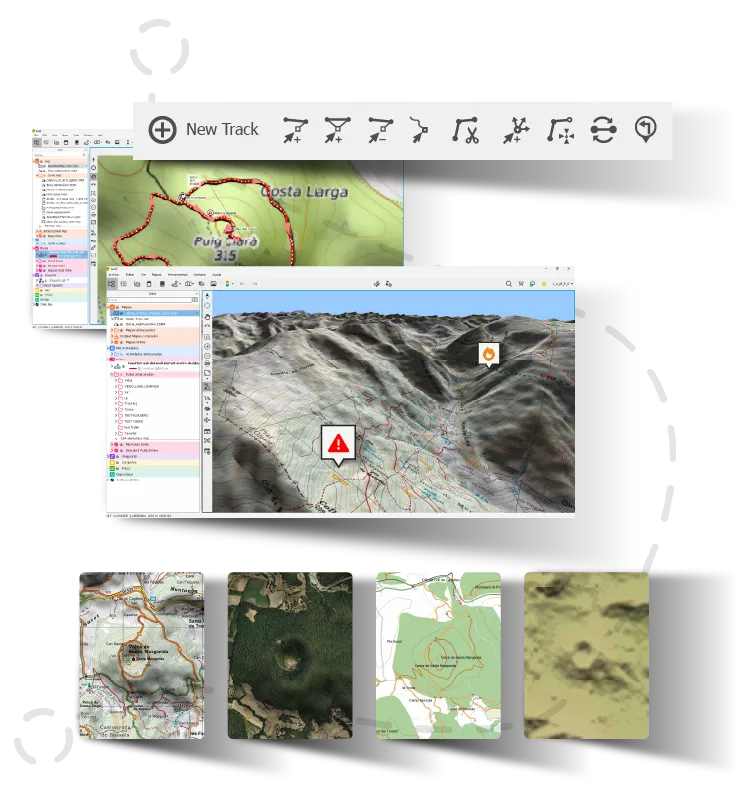
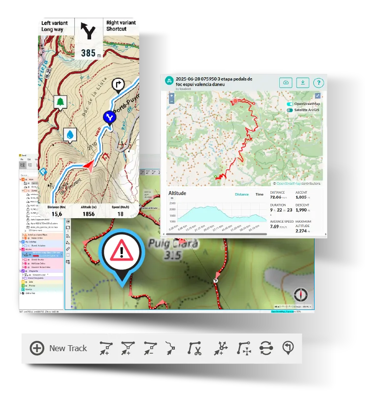
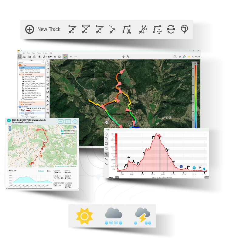
TwoNav has over 20 years of experience offering tailored geolocation solutions
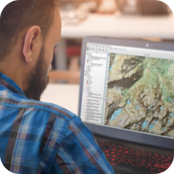
We customize our solutions for professional clients by adapting our products to the needs of their sector and offering them continuous long-term support. TwoNav stands out in the professional field thanks to its comprehensive connected ecosystem that integrates GPS devices, planning software, mobile applications, high-quality maps, and other services, especially catering to the following professional sectors:


Security Forces
Military, Police, Army, Private Surveillance...
TwoNav has an ecosystem of products adapted to the needs of various State Security Forces to guarantee orientation and geolocation services. With custom developments tailored to the requirements of each force, TwoNav offers robust GPS devices with navigation functionalities based on the most detailed maps of each geographical area.
|
|
Rugged hardware: GPS devices designed to withstand shocks, impacts, and extreme conditions. Total reliability even in extended operations or hostile environments. |
|
|
Multiple positioning systems: Maximum accuracy at all times thanks to triangulation from multiple global systems (GPS, Galileo, Glonass, and Beidou). Ideal for missions in areas with limited coverage. |
|
|
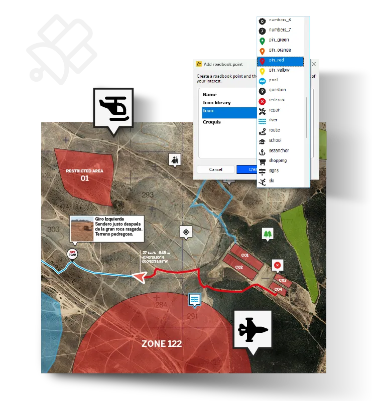
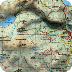
Accurate offline maps for total coverage: High compatibility with all types of mapping (topographic, urban, orthophotos). Creation of custom maps with restricted areas and exclusion zones. |
|
|
Unlimited waypoints for marking references: Marking of strategic points, incidents, or surveillance areas without restrictions and with all necessary references to navigate unknown terrains. |
|
|
Accurate navigation anywhere: Route planning and navigation with precision and detail from a single environment – essential in critical operations where evaluating multiple options is crucial. |
Other features and tools
-
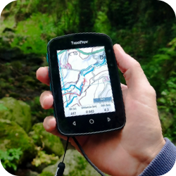
GPS Range
Devices built for demanding conditions, MIL-STD 810 certified, IP68 rated, sunlight-readable and night-vision compatible screen, physical buttons for glove use, and kill switch function for immediate shutdown in critical situations. -
Coordinates & Datums
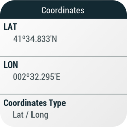
Compatible with a wide range of coordinate systems and datums, allowing use in any environment and adaptation to local cartographic standards. -
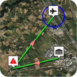
Detailed route planning
Planning secure and coordinated missions with drones, ground patrols, or tactical deployments. Route creation with maximum detail and precision using the Land planner.

GPS Range
Devices built for demanding conditions, MIL-STD 810 certified, IP68 rated, sunlight-readable and night-vision compatible screen, physical buttons for glove use, and kill switch function for immediate shutdown in critical situations.

Coordinates & Datums
Compatible with a wide range of coordinate systems and datums, allowing use in any environment and adaptation to local cartographic standards.

Detailed route planning
Planning secure and coordinated missions with drones, ground patrols, or tactical deployments. Route creation with maximum detail and precision using the Land planner.
Emergency Services
Firefighters, Mountain Rescue Teams, Rescue Helicopter...
For more than 20 years, TwoNav has been equipping the Emergency Services of various European countries with GPS navigation and tracking systems, as well as providing operation centres with the powerful Land software to monitor units.
|
|
Rugged and durable devices: Resistant devices that are easily operable in extreme temperature environments and waterproof. Designed to withstand shocks, water, dust and high temperatures. |
|
|
Maps always available without network coverage: Access to high-quality offline maps for remote areas, high mountains and even maritime zones. Essential for critical situations without relying on mobile coverage. |
|
|
3D view for greater realism of the area: Ideal for planning air or ground routes in rugged, hard-to-access areas. Essential for understanding terrain and elevation changes clearly before launching a rescue. |
|
|
Management of danger or exclusion zones: Ability to mark dangerous or restricted areas on the map (landslides, active fires, maritime currents) to alert the team and optimise interventions by avoiding additional risks. |
|
|
Automatic route calculation: Route generation in just a few clicks, allowing selection of the fastest and safest path depending on terrain conditions — even under pressure and without wasting time. |
Other functions and tools
-
Map variety
Easy identification of obstacles or risk sources with aerial imagery of the terrain. Crucial for fires or complex urban areas. -
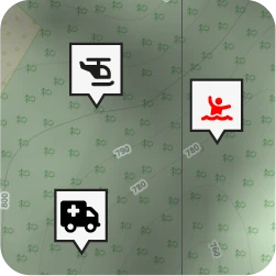
Waypoints and references
Marking of key points: injured people, obstacles, safe zones or hazard sources. -
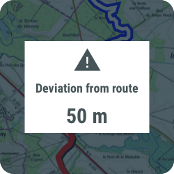
Visual and audible alarms
Immediate alerts for deviations, danger zones or arrival at key points. Safety for the team during every stage of the mission.

Map variety
Easy identification of obstacles or risk sources with aerial imagery of the terrain. Crucial for fires or complex urban areas.

Waypoints and references
Marking of key points: injured people, obstacles, safe zones or hazard sources.

Visual and audible alarms
Immediate alerts for deviations, danger zones or arrival at key points. Safety for the team during every stage of the mission.
Forest Rangers
Environmental agents, Rural guards, Forest inspectors...
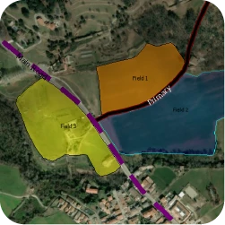
Forestry services have in Land their best ally: detailed cartographic analysis, map overlays, annotations, and countless precise functions for working in forests and wooded areas. Rangers carry out field analysis using large GPS devices to reinforce information at key points of interest.
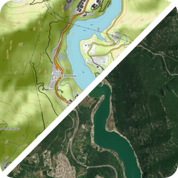
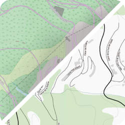
| Wide variety of maps for better site knowledge: The high cartographic compatibility allows choosing the most suitable map (topo, orthophoto, road...) depending on the operational environment. Just open multiple maps simultaneously, compare them and extract the most complete information. | |
| Unlimited waypoints to georeference areas: Essential for planning operations in areas where a database of key site points is needed: risk zones, restricted access areas, hunting grounds, shelters... | |
| Area calculation to map working zones: Integrated tool for fast and accurate surface measurement, useful in evaluating logging, reforestation, or protected zones. | |
| Automatic route creation in seconds: Automatically generate routes over existing paths, both dirt and paved, with manual editing options to adapt the itinerary to service needs. | |
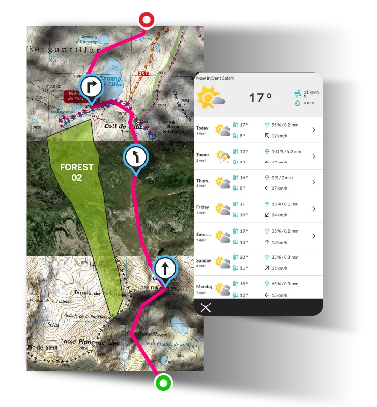
| Hourly weather forecast: Access to real-time weather information — a key element for the safe planning of field operations. | |
Other functions and tools
-
Format compatibility
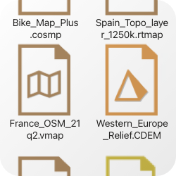
TwoNav and Land are compatible with the most common track formats (.GPX, *.TRK...) and map formats (*.IMP, *.KML, *.KMZ, *.MPVF, *.RMAP, *.RTMAP, *.VMAP...). -
Create maps with your own data
In areas where official maps do not reflect all paths and shortcuts, incorporate local data to generate custom maps adapted to the terrain reality. -
Live position broadcast
Real-time tracking of team members. Better coordination to respond to emergencies in remote areas and ensure their safety.

Format compatibility
TwoNav and Land are compatible with the most common track formats (.GPX, *.TRK...) and map formats (*.IMP, *.KML, *.KMZ, *.MPVF, *.RMAP, *.RTMAP, *.VMAP...).

Create maps with your own data
In areas where official maps do not reflect all paths and shortcuts, incorporate local data to generate custom maps adapted to the terrain reality.

Live position broadcast
Real-time tracking of team members. Better coordination to respond to emergencies in remote areas and ensure their safety.
Active Tourism
Country houses, Campsites, Cultural initiatives...
Hotels and country houses find in the TwoNav Ecosystem the perfect ally to showcase the best routes in the region, whether for cycle tourism or hiking. Tourist establishments open an account on the TwoNav Cloud, containing all the local routes, allowing them to create enriched itineraries with Land and offer them to guests either through rental GPS devices or via the TwoNav app.
|
|
Route creation tailored to different profiles: Generation of various versions of the same route adapted to the effort level, experience, or time availability of each guest, offering unique experiences for each profile. |
|
|
Routes with instructions for clients navigating the itineraries: Generation of interactive roadbooks with precise directions, images, and descriptions to make self-guided navigation easier for guests. |
|
|
Wide range of online and offline maps for all activities: Availability of multiple types of maps to plan and navigate routes according to the nature of the activity or guest profile. Maps accessible even without an internet connection. |
|
|
Routes stored in a secure and reliable space: Safe storage of routes and roadbooks in the TwoNav Cloud, with instant access and the ability to update them for future events or guest groups. |
|
|
Emergency alerts for enhanced guest safety: Alert system with exact location to respond to incidents or emergency situations. |
Other functions and tools
-
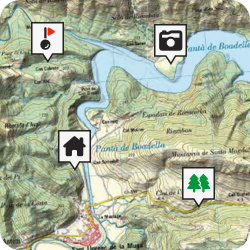
Points of interest (Waypoints)
Identification of key points along the route, such as viewpoints, rest areas, or cultural landmarks to enrich the visitor’s experience. -
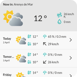
Integrated weather forecast
Very useful for guests unfamiliar with local weather. They can adapt their activities according to the climate, ensuring safety at all times. -
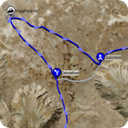
A plan B for every route
Inclusion of route variants with planned detours or optional visits. Having alternative routes and shortcuts will be very helpful in case of changes or unforeseen events.

Points of interest (Waypoints)
Identification of key points along the route, such as viewpoints, rest areas, or cultural landmarks to enrich the visitor’s experience.

Integrated weather forecast
Very useful for guests unfamiliar with local weather. They can adapt their activities according to the climate, ensuring safety at all times.

A plan B for every route
Inclusion of route variants with planned detours or optional visits. Having alternative routes and shortcuts will be very helpful in case of changes or unforeseen events.
Educational Institutions
Primary and secondary schools, Vocational training centres, Sports federations...
More and more educational centres and sports federations are integrating TwoNav’s GPS technology into their training programmes, especially in activities related to orienteering, mountain sports or environmental education. Thanks to the Land software, teachers and instructors create custom routes, analyse tracks and prepare practical exercises. Students, in turn, use GPS devices to carry out educational outings.
|
|
Easy map handling for beginners: Access to online and offline maps, with the option to create custom maps tailored to educational objectives, adapting activities to the environment or teaching content. |
|
|
Intuitive route creation: Automatic route generation in just a few clicks to streamline the preparation of training or sports itineraries. Advanced track editing allows modifying their layout and converting them into roadbooks enriched with directions and on-site maneuvers. |
|
|
Alternative routes to ensure maximum safety: Including route variants offers shortcuts and alternative paths depending on the group’s level, terrain conditions, or the pedagogical goals of the activity. |
|
|
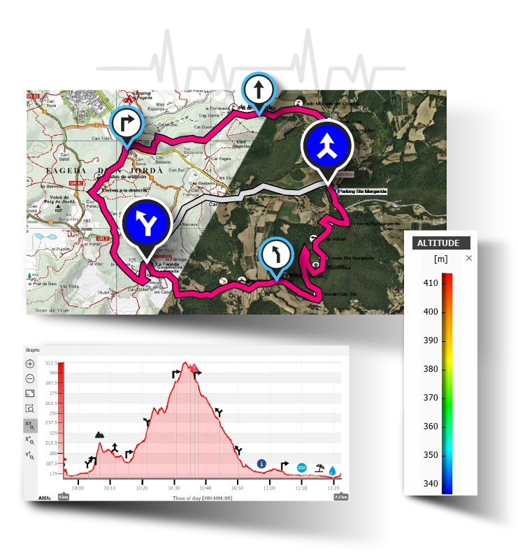
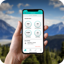
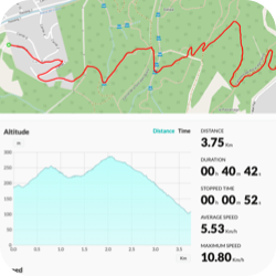
The best data for activity analysis: Detailed and real-time analysis of over 200 data points in graphs, segments, and colour gradients. Very useful for evaluation work or physical-sports analysis. |
|
|
Accurate navigation with waypoints: In unfamiliar terrain, marking reference points is key to assisting group orientation, highlighting nearby shelters, points of interest, and key areas for learning. |
Other functions and tools
-
The best routes on the web
Access to specialised outdoor route providers to choose suitable tracks for each activity (Wikiloc, Komoot, TwoNav GO...). -
Compatibility with many formats
Flexible use of various track formats (.GPX, *.TRK...) and map formats (*.IMP, *.KML, *.KMZ, *.MPVF, *.RMAP, *.RTMAP, *.VMAP...). Allows easy and convenient use for all types and levels of users. -
Virtual cloud to store all your tracks
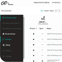
Centralised storage of routes on a secure and reliable server accessible from anywhere in the world via the internet.

The best routes on the web
Access to specialised outdoor route providers to choose suitable tracks for each activity (Wikiloc, Komoot, TwoNav GO...).

Compatibility with many formats
Flexible use of various track formats (.GPX, *.TRK...) and map formats (*.IMP, *.KML, *.KMZ, *.MPVF, *.RMAP, *.RTMAP, *.VMAP...). Allows easy and convenient use for all types and levels of users.

Virtual cloud to store all your tracks
Centralised storage of routes on a secure and reliable server accessible from anywhere in the world via the internet.
Sports Event Organizer
Orienteering races, Triathlons, Trailbuilders...
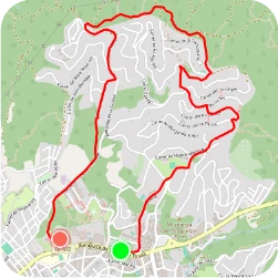
TwoNav is the reference tool for planning and managing outdoor sports events. Organisers of orienteering races, mountain competitions or endurance events rely on the TwoNav Ecosystem to design precise routes, monitor participant positioning in real time and ensure race safety. TwoNav offers a complete solution for every phase of the event.
| Navigation tools for all types of races: Robust GPS devices with multiple navigation options: track following, heading navigation without boundaries... | |
| Route creation and editing: Automatic route generation with editing tools to customise layouts, adjust difficulty levels and optimise paths based on the event’s needs. | |
| Monitoring of 200+ data points: Analysis of key data such as heading, speed, altitude, gradients and deviations, with detailed graphs and segments to design safe, balanced and competitive routes. | |
| Virtual cloud to store and share routes: TwoNav Cloud is a space to store all routes and access them instantly from Land, TwoNav GPS or the TwoNav app. From the cloud, you can also easily share race tracks with participants and the technical team. | |
| Always up-to-date weather forecast: Integrated weather forecast to anticipate climate changes, adapt routes or make strategic decisions before and during the event. | |
Other functions and tools
-
The best map according to terrain
Wide variety of maps to choose from depending on the terrain where the race takes place, including topographic, satellite or customised options, allowing for accurate planning tailored to the event’s environment. -
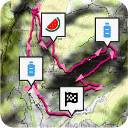
Waypoints along the route
Easy marking of checkpoints, refreshment stations or technical zones along the route, simplifying logistics and event control. All points of interest are saved in a single file compatible with Land, TwoNav GPS and the TwoNav app. -
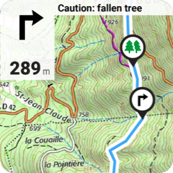
Roadbook instructions
Digital roadbooks provide clear and precise manoeuvres to ensure that participants follow the designated route independently and safely. As easy as just following the guidance.

The best map according to terrain
Wide variety of maps to choose from depending on the terrain where the race takes place, including topographic, satellite or customised options, allowing for accurate planning tailored to the event’s environment.

Waypoints along the route
Easy marking of checkpoints, refreshment stations or technical zones along the route, simplifying logistics and event control. All points of interest are saved in a single file compatible with Land, TwoNav GPS and the TwoNav app.

Roadbook instructions
Digital roadbooks provide clear and precise manoeuvres to ensure that participants follow the designated route independently and safely. As easy as just following the guidance.


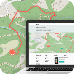
TwoNav Ecosystem
TwoNav accompanies you at every stage for a complete and safe experience from start to finish
-
1. Prepare
Download Land and carefully plan the itinerary for your next outing. -
2. Connect
Pair your GPS with the TwoNav Link App to sync activities, receive WhatsApp messages and calls. -
3. Navigate
Explore the mountains with the experience and safety of a TwoNav GPS: orientation, precision, and reliability. -
4. Discover
Zoom in on the map and find alternative paths. Mark as many waypoints as you need. -
5. Broadcast
Share your location in real time wherever you are. Ensure your safety. -
6. Analyse
Sync your latest activity with the TwoNav Cloud. Store your tracks in a secure and reliable space.

1. Prepare
Download Land and carefully plan the itinerary for your next outing.

2. Connect
Pair your GPS with the TwoNav Link App to sync activities, receive WhatsApp messages and calls.

3. Navigate
Explore the mountains with the experience and safety of a TwoNav GPS: orientation, precision, and reliability.

4. Discover
Zoom in on the map and find alternative paths. Mark as many waypoints as you need.

5. Broadcast
Share your location in real time wherever you are. Ensure your safety.

6. Analyse
Sync your latest activity with the TwoNav Cloud. Store your tracks in a secure and reliable space.

Full Feature Table
All the functions of the TwoNav Tools Ecosystem
|
Land |
GPS |
App TwoNav |
||
| Included maps | ||||
| Online maps | ||||
| Maps Plus online | ||||
| Routable OpenStreetMap maps | ||||
| Open maps | ||||
| Open maps from the TwoNav store | ||||
| Open personal maps (*.RMAP, *.MPV/*.MPVF) | ||||
| Advanced map compatibility (*.ECW, *.MBTiles, *.TIFF-COG, *.GPKG) | ||||
| Import maps (*.SHP, *.SID, *.TIFF..) | ||||
| Automatic cache of downloaded online map tiles | ||||
| Work with multiple maps simultaneously, multilayer and transparency | ||||
| Automatically open the best map for the current position | ||||
| Edit maps | ||||
| Create maps from images or paper maps | ||||
| Create local maps from online maps | ||||
| Create map sections from larger maps | ||||
| Create hypermaps (composed of multiple maps on different layers) | ||||
| Merge multiple maps | ||||
| Create/Edit vector maps (points, polylines, polygons) | ||||
| Create/Edit vector map layers | ||||
| Add routing capability to custom vector maps | ||||
| Explore maps | ||||
| Explore maps smoothly | ||||
| View maps in 3D | ||||
| Apply 2D relief shading | ||||
| Toggle map (toolbar) | ||||
| Orient map North Up / Track Up (toolbar) | ||||
| Measure distances, elevations and bearings on the map | ||||
| Measure distance with multipoint tool | ||||
| Open tracks | ||||
| Open tracks in various formats (*.TRK, *.BTRK, *.GPX, *.RTE, *.KML/*.KMZ) | ||||
| Access online track providers (Strava, Komoot, Sunto, Utagawa...) | ||||
| Open multiple tracks simultaneously | ||||
| Import tracks (*.TXT, *.CSV) | ||||
| Edit tracks | ||||
| Customize track properties (color, thickness, description...) | ||||
| Create/Edit tracks point by point | ||||
| Automatically create tracks (FastTrack) | ||||
| Create roadbooks | ||||
| Create tracks by freehand drawing | ||||
| Laps analysis | ||||
| Color tracks based on variables (altitude, speed, pulse...) | ||||
| Merge several tracks | ||||
| Advanced track tools (reverse track, recalculate altitude, assign times...) | ||||
| Explore tracks | ||||
| Advanced track properties (distances, speeds, altitudes, sensors...) | ||||
| Track points list | ||||
| Graph: Analyze altitude profile | ||||
| Graph: Explore the graph | ||||
| Graph: Display multiple tracks and waypoints simultaneously | ||||
| Graph: Map-graph interaction to locate points | ||||
| Attach files to tracks (image, audio, video, text...) | ||||
| Manage locations | ||||
| Open default waypoint file | ||||
| Create waypoints (on map, by coordinates, heading...) | ||||
| Open multiple waypoint files simultaneously (*.WPT, *.GPX, *.KML/*.KMZ) | ||||
| Create waypoint files | ||||
| Read geocaching files (descriptions, categories, hints...) | ||||
| Edit waypoint properties (name, icon, radius, description...) | ||||
| Attach files to waypoints (image, audio, video, text...) | ||||
| Search POI | ||||
| Search by address (street, number...) | ||||
| Search by coordinates | ||||
| Import reference points (*.TXT, *.CSV) | ||||
| Record activities | ||||
| Record tracks during activities | ||||
| Monitor activity data fields (distance traveled, ascent, time...) | ||||
| Set alarms for data fields (speed, altitude, heart rate...) | ||||
| Customize track recording (point frequency, format, color...) | ||||
| Navigate activities | ||||
| Navigate tracks | ||||
| Navigate to a place | ||||
| Navigate RTE routes | ||||
| Navigate roadbooks | ||||
| Automatically calculate route to a destination (Autoroute) | ||||
| Return to the activity starting point | ||||
| Monitor data fields during navigation (remaining distance, ascent, time...) | ||||
| Route deviation alarm | ||||
| Proximity alarm to reference point | ||||
| Graph: View route graph with current position | ||||
| Graph: Add a graph view to the map page | ||||
| Visual compass with heading to destination | ||||
| Training | ||||
| Train by time or distance | ||||
| Train against yourself (TrackAttack) | ||||
| External sensor data fields (HR, Cad, Spd, Pow) | ||||
| Recorded sensor data fields in activity track | ||||
| Heart rate zone data fields | ||||
| Activity data fields (distance, ascent, time, calories...) | ||||
| Graph: Custom variables (HR, speed...) | ||||
| Customize | ||||
| Create sport profiles | ||||
| Customize data fields | ||||
| Work with multiple data and coordinate systems | ||||
| Available in other languages | ||||
| Full customization | ||||
| Connections | ||||
| TwoNav Cloud storage | ||||
| Weather forecast: By location | ||||
| Weather forecast: Weather maps | ||||
| Third-party services (Strava, Komoot, Suunto, GDrive, DropBox, IGN...) | ||||
| Dropbox linking | ||||
| Amigos | ||||
| Connect external sensors (HR, Cad, Spd, Pow) | ||||
| Transfer files from GPS devices | ||||
| Connect to an external GPS to know current position | ||||
| Land Interface | ||||
| Data tree for agile management of multilevel files | ||||
| Multiple windows for simultaneous view of information (graphs, properties...) | ||||
| Activity calendar | ||||
| Customize menus and toolbars | ||||
| Others | ||||
| No advertising | ||||
| Automatic georeferencing of photos (PhotoGPS) | ||||
| SEE LAND | SEE TWONAV GPS | SEE TWONAV APP | ||
Contact TwoNav
Contact us for more information
Thank you for contacting us, we will contact you shortly.
TwoNav, Made in Spain

 Secure Payment
 Free shipping on orders over €60 (EU)
 Hassle-free returns