 Secure Payment
 Free shipping on orders over €60 (UE)
 Financing on orders +60 €
 Hassle-free returns
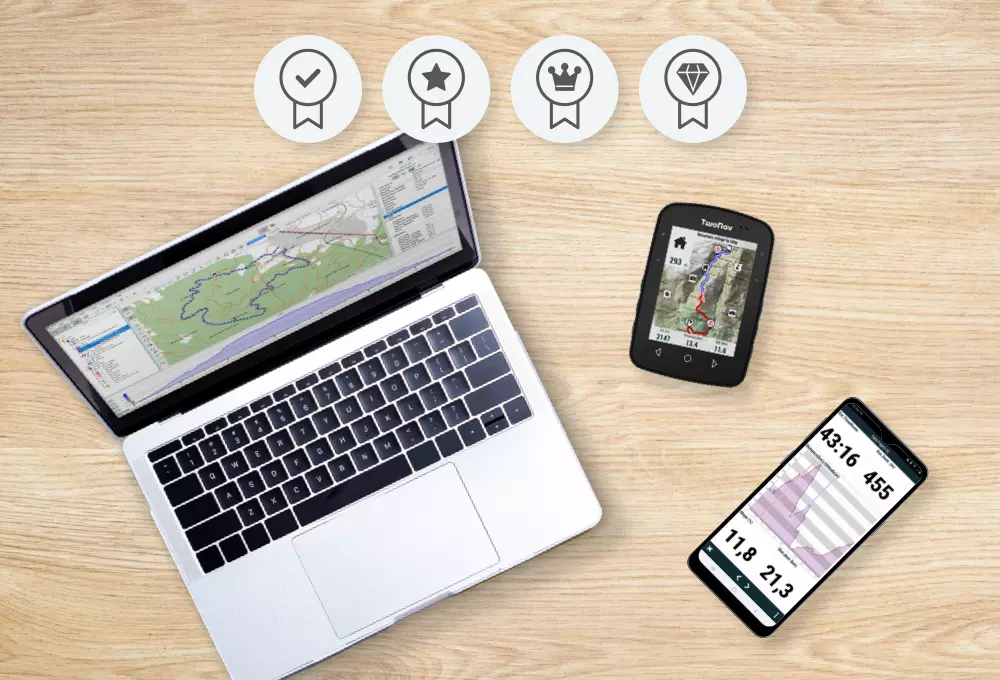
Everything you need to enjoy the Mountain from start to finish
Enjoy a set of tools that will allow you to plan, navigate and analyze your routes through the mountains with precise and detailed preparation.
Dare to create routes through unknown places and let yourself be guided with the security of having reliable maps and alternative routes. No matter your sport or your level, when you go out to discover them you will know your position at all times and you will have the most relevant data in real time: waypoints, shortcuts, distances, altitudes, efforts...
A TwoNav subscription includes: Land, App TwoNav, High-quality online and offline maps, Weather forecast, SeeMe™ via Link app, TwoNav Cloud...
New App TwoNav 6 version included!
Prepare
Do it with Land, the most reliable PC/Mac software for planning your routes accurately on high-quality maps
-
Find the perfect route or create your own
Land makes it easy for you to create and edit routes from around the world. Connect to the most popular route providers (Wikiloc, Komoot, OpenRunner, UtagawaVTT, IGN Rando...), download your routes and edit them to your liking.
You can also create your own routes from scratch with tools that will create your route automatically (FastTrack).
Cut, lengthen and enrich your routes with shortcuts, variants and indications with roadbook points that will be very useful when you are in the mountains and must adapt to unforeseen events (tiredness, road conditions, weather...).
When your route is ready, it will be synchronized with the TwoNav Cloud and it will be downloaded to the TwoNav App. Your adventure starts now!
In the mountains, good preparation is essential
-
Work on any map
If you don't have cartography of the area, Land provides you with the best free and paid maps in the world (Ordnance Survey, TomTom, IGN...). Open different maps at the same time and get the best out of them: arrange their layers, add transparency and show them in 3D. Also, if you have your own fonts, convert them to other formats
-
 New
New
Weather forecast
Get informed about the weather forecast while planning your route. Check the weather forecast for a specific location several days in advance or, if you prefer, consult specialized weather maps with information on precipitation, cloud cover, wind...
-
Mark your own waypoints
Anticipate and highlight the most important places of your itineraries directly on the map. Mark waypoints and organize them into collections to find them easily. You can import waypoints or create them yourself, either on the map or by entering coordinates. Attach text, image or sound to have all the information you need
-
 New
New
Automatically create routes with FastTrack
Subscriptions include the OpenStreetMap, a high-quality map with worldwide coverage that includes urban roads and mountain paths in each country. Use it to create your routes in a few clicks, simply mark the starting and ending points. The FastTrack function will generate your route and add waypoints at the most important maneuvers along the itinerary
-
Enhance your routes
Turn your routes into true digital roadbooks with extra information about the most relevant points or places you want to visit, whether maneuvers, comments, photographs, or videos. Prepare different alternative paths on your route so you can adapt your itinerary to any unexpected situations: fatigue, road conditions, weather...
-
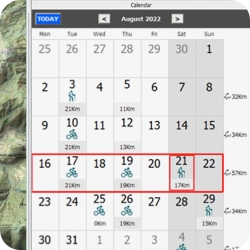
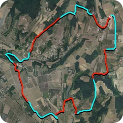
Your scheduled routes
It has never been so easy to retrieve one of your outings, just open the calendar and go back to that day. Your activities and waypoints will be displayed in a practical calendar view with the most relevant data and statistics for periods of time. Double click to automatically download your output and start working on it

Work on any map
If you don't have cartography of the area, Land provides you with the best free and paid maps in the world (Ordnance Survey, TomTom, IGN...). Open different maps at the same time and get the best out of them: arrange their layers, add transparency and show them in 3D. Also, if you have your own fonts, convert them to other formats
 New
New
Weather forecast
Get informed about the weather forecast while planning your route. Check the weather forecast for a specific location several days in advance or, if you prefer, consult specialized weather maps with information on precipitation, cloud cover, wind...

Mark your own waypoints
Anticipate and highlight the most important places of your itineraries directly on the map. Mark waypoints and organize them into collections to find them easily. You can import waypoints or create them yourself, either on the map or by entering coordinates. Attach text, image or sound to have all the information you need
 New
New
Automatically create routes with FastTrack
Subscriptions include the OpenStreetMap, a high-quality map with worldwide coverage that includes urban roads and mountain paths in each country. Use it to create your routes in a few clicks, simply mark the starting and ending points. The FastTrack function will generate your route and add waypoints at the most important maneuvers along the itinerary

Enhance your routes
Turn your routes into true digital roadbooks with extra information about the most relevant points or places you want to visit, whether maneuvers, comments, photographs, or videos. Prepare different alternative paths on your route so you can adapt your itinerary to any unexpected situations: fatigue, road conditions, weather

Your scheduled routes
It has never been so easy to retrieve one of your outings, just open the calendar and go back to that day. Your activities and waypoints will be displayed in a practical calendar view with the most relevant data and statistics for periods of time. Double click to automatically download your output and start working on it

-
Trust the TwoNav App, it will always show you the way to go
As soon as you run the App, download the route that you have prepared in Land and you will be ready to go out and explore it.
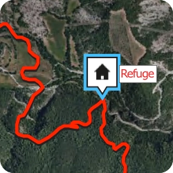
On the screen of your smartphone you will see the map of the area, your position in real time, the waypoints of the route, roadbook indications and alternative routes.
If you need to, change the map to a more precise one, where you will find the points of interest closest to your position. Use it as a reference to adapt your activity in unknown terrains.
At any time you can change the destination of your route or return to the starting point, the App will show you the way back.
-
Trust the TwoNav App, it will always show you the way to go
As soon as you run the App, download the route that you have prepared in Land and you will be ready to go out and explore it.
On the screen of your smartphone you will see the map of the area, your position in real time, the waypoints of the route, roadbook indications and alternative routes.
If you need to, change the map to a more precise one, where you will find the points of interest closest to your position. Use it as a reference to adapt your activity in unknown terrains.
At any time you can change the destination of your route or return to the starting point, the App will show you the way back.
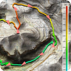
Orientation in the mountains wherever you are
-
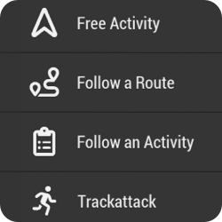
Types of navigation
The TwoNav app offers you several navigation types, choose the one that best suits your activity: free navigation, follow a track, navigate a roadbook, drive on roads with voice guidance, go to specific coordinates, compass navigation...
-
Choose the path that suits you best
What might seem like a sunny day can turn into a rainy day at any time. If when preparing your route with Land, you have added variants, now you can shorten your path according to the circumstances of the moment with the security of not improvising, you yourself will have planned alternative routes in your itinerary
-
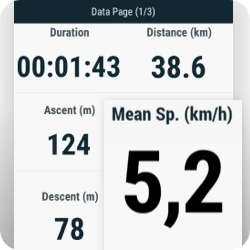
+200 live data
Control your performance in real time and thus adapt your efforts to the remainder of the route. The data pages show you more than 200 data in real time (height, distance, ascent, power, speed...). Also, if you have a heart rate monitor or cadence monitor, connect it and you will receive even more information
-
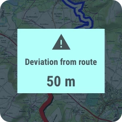
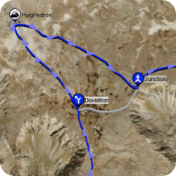
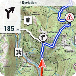
Receive notifications when deviating from route
Deviating from the route will no longer be a problem, the App will notify you so you can redirect your activity. It will also alert you when you exceed speed or heart rate limits. In addition, if during the preparation with Land you have added waypoints to your route, when you approach them, you will also be alerted
-
 New
New
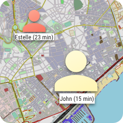
Broadcast your position live
With Amigos™, you and your group can share your locations in real time, viewable both from the TwoNav App while navigating and from Land while planning or analyzing at home. This exclusive TwoNav feature ensures both your safety and your loved ones' peace of mind.
-
 New
New
Emergency alerts
In unknown or risky situations, calling for help is essential. With the SeeMe™ service, in addition to broadcasting your activity, you can also send emergency alerts from the TwoNav App or from a TwoNav GPS via App Link. This way, your contacts will know your exact location at all times.

Types of navigation
The TwoNav app offers you several navigation types, choose the one that best suits your activity: free navigation, follow a track, navigate a roadbook, drive on roads with voice guidance, go to specific coordinates, compass navigation...

Choose the path that suits you best
What might seem like a sunny day can turn into a rainy day at any time. If when preparing your route with Land, you have added variants, now you can shorten your path according to the circumstances of the moment with the security of not improvising, you yourself will have planned alternative routes in your itinerary

+200 live data
Control your performance in real time and thus adapt your efforts to the remainder of the route. The data pages show you more than 200 data in real time (height, distance, ascent, power, speed...). Also, if you have a heart rate monitor or cadence monitor, connect it and you will receive even more information

Receive notifications when deviating from route
Deviating from the route will no longer be a problem, the App will notify you so you can redirect your activity. It will also alert you when you exceed speed or heart rate limits. In addition, if during the preparation with Land you have added waypoints to your route, when you approach them, you will also be alerted
 New
New
Broadcast your position live
With Amigos™, you and your group can share your locations in real time, viewable both from the TwoNav App while navigating and from Land while planning or analyzing at home. This exclusive TwoNav feature ensures both your safety and your loved ones' peace of mind.
 New
New
Emergency alerts
In unknown or risky situations, calling for help is essential. With the SeeMe™ service, in addition to broadcasting your activity, you can also send emergency alerts from the TwoNav App or from a TwoNav GPS via App Link. This way, your contacts will know your exact location at all times.

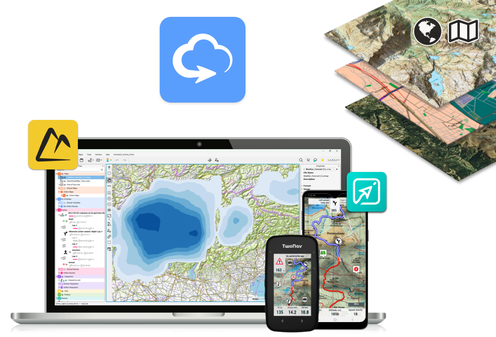
Analyze
Synchronize your activities and you will be able to analyze them from all platforms: Land, App TwoNav and TwoNav Cloud

Connect with the world: Share your outings on social networks
Don't wait to get home, as soon as you finish your activity, synchronize it with the TwoNav Cloud and it will be automatically published on your favorite networks (Strava, Komoot, TrainingPeaks...). All your friends and the whole TwoNav community will be participants in your activities.
Your routes will be saved in the TwoNav Cloud, a safe and reliable place where all your activities will be stored. From go.twonav.com you will analyze from anywhere in the world the most relevant data of your outings: layout, height, distance, speed, slope...
When you get home, analyse your activity in more depth with Land.
3 ways to take a deeper look at your rides with Land
-
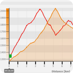
Graphics
The fastest way to analyze your outputs is by using Land plots. In them you can compare several tracks at the same time and even change the values of the graph axes for others that interest you more (altitude, speed, heart rate...)
-
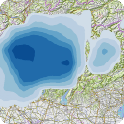
Color gradient
If you want to parse a single value across your output, use the color gradient. Select a parameter to analyze (slope, pulsations...) and the track will be colored according to the data collected for that field from the beginning to the end of the route. In a visual way, you will quickly locate the key points in your exit
-
Laps and Subtracks
If you are one of those who goes out to train and analyzes each section of your training, with Land you will be able to analyze specific sections and mark the sections that you want to distinguish permanently. You can also automatically divide them by time or distance according to your analysis

Graphics
The fastest way to analyze your outputs is by using Land plots. In them you can compare several tracks at the same time and even change the values of the graph axes for others that interest you more (altitude, speed, heart rate...)

Color gradient
If you want to parse a single value across your output, use the color gradient. Select a parameter to analyze (slope, pulsations...) and the track will be colored according to the data collected for that field from the beginning to the end of the route. In a visual way, you will quickly locate the key points in your exit

Laps and Subtracks
If you are one of those who goes out to train and analyzes each section of your training, with Land you will be able to analyze specific sections and mark the sections that you want to distinguish permanently. You can also automatically divide them by time or distance according to your analysis

All that you need is included in a TwoNav subscription
All the tools of the TwoNav Ecosystem united under the same subscription: - Land software: Preparation of outdoor outings from your PC - TwoNav App: Orientation and navigation on your smartphone - Maps: High-quality online and offline maps in multiple formats (topo, orthophoto, reliefs...) with urban roads and mountain roads from around the world - Weather forecast: Check the weather forecast for the place you are going to visit several days in advance while you prepare the route - SeeMe™: Service to share live location and send emergency alerts in the TwoNav App and via the Link App on TwoNav GPS - TwoNav Cloud: Your virtual storage space in the TwoNav Cloud
Advantages of having a subscription
You decide where to use your subscription and for how long. No compromises. Maximum comfort for you: - Updates: You will always have the latest version and latest news - Multiplatform: use it on up to 5 devices (PC, Mac, smartphone...) - Upgrades: You decide when to change to a better plan - Annual charge: Forget worries, a single charge, automatic renewal - Cancellation: Cancel or resume your subscription whenever you want

Learn from Lena Berger’s tips
Discover the methods and tricks Lena uses when exploring new areas with a TwoNav subscription
Get started!DISCOVER THE TWONAV SUBSCRIPTION PLANS
Experience more for less. Try PRO for free for 30 days
Try PRO features for 30 days for free. Once over, FREE plan will be activated. No credit card required
Free
$0- Record your activities in the TwoNav App
- Analyze a route or activity on your smartphone (TwoNav App) or on your computer (Land) with basic data
- Use the free online maps and your purchased maps
- 30 MB of space in TwoNav Cloud to store your files
Try PRO features for 30 days for free.
No credit card required
- No advertising
- Open multiple routes simultaneously
- Create routes in the TwoNav App with simple tools
- Navigate your routes with distance, time, and ascent data to your destination.
- Receive alerts when deviating from the route
- Find the way back at any time
- Automatically save online maps for faster future access (cache 100 MB)
- SeeMe™ service to share live location and send emergency alerts (TwoNav App or TwoNav GPS via Link App)
- 250 MB of storage in TwoNav Cloud to save your files
Cancel anytime
Automatic renewal until cancellation
View terms and conditions
- Create routes in Land or the TwoNav App with advanced tools (AutoRoute, FastTrack, Roadbooks, Variants...)
- Download OSM maps worldwide to calculate routes and work offline
- Maps Plus online, fast, and reliable
- Weather forecast for any location
- Stunning 3D views of your maps and routes
- Switch maps quickly from the map window
- Open personal maps in *.RMAP, *.MPV, *.MPVF formats
- Work with different collections of waypoints
- Advanced settings (data fields, alarms, profiles...)
- Amigos™ service to locate and communicate with other users
- 1 GB of storage in TwoNav Cloud to save your files
Cancel anytime
Automatic renewal until cancellation
View terms and conditions
- * Open maps from other sources in *.ECW, *.MBTiles, *.TIFF(COG) format in Land and App
- Weather forecast maps for temperature, cloud cover, and precipitation
- Create vector maps to mark trails, points of interest, and exclusion zones
- Create hypermaps by combining multiple maps into one for easy access
- Import maps in advanced formats *.SHP, *.SID, *.TIFF...
- Generate offline maps for your GPS/App TwoNav from online maps
- Create your own maps from images
- Connect GPS from other brands and get your current position in Land
- 5 GB of storage on TwoNav Cloud to save your files
* Maps compatible with Land and App. The rest of the advanced map functions are available only in Land.
Cancel anytime
Automatic renewal until cancellation
View terms and conditions

Know the opinion of the specialized press
-

Land: For all kinds of sportmen
Land 9 is the perfect software for all those cycling or mountaineering fans who want to explore new routes with maximum precision and safety, whether it be hiking, mountaineering, mountain biking, gravel, road or even bikepacking
Solo Bici
Spain -

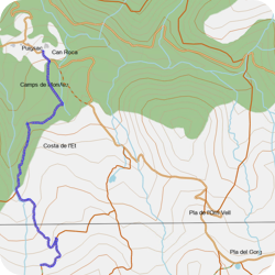
Land: Very useful to create variants in your routes
It is very practical that a route can contain different variants, so that you can have several alternatives for the same route. For example, a longer and a shorter route variant, or a variant with optional stops at certain places of interest. In addition, the routes calendar has a view in which routes, waypoints and activities can be displayed according to their creation date
Pocket Navigation
Germany -

TwoNav App: Tracks and Maps
Transferring and recording a new activity is very intuitive and you can easily follow your progress on a very readable screen. Following a route previously loaded on the device is also very easy. The purchase of maps is very easy through the website. They can then be uploaded to your device.
Rando Zone
France -

Maps Plus: High-quality, easy-to-use maps
The most important thing is its ability to download, store and process the topography of the target area during the activity, so that the orientation quality will be maximum according to our needs, whether they are mountaineering, hiking, trail or mountain biking.


-
Land: For all kinds of sportmen
Land 9 is the perfect software for all those cycling or mountaineering fans who want to explore new routes with maximum precision and safety, whether it be hiking, mountaineering, mountain biking, gravel, road or even bikepacking
Solo Bici
Spain -
Land: Very useful to create variants in your routes
It is very practical that a route can contain different variants, so that you can have several alternatives for the same route. For example, a longer and a shorter route variant, or a variant with optional stops at certain places of interest. In addition, the routes calendar has a view in which routes, waypoints and activities can be displayed according to their creation date
Pocket Navigation
Germany -
TwoNav App: Tracks and Maps
Transferring and recording a new activity is very intuitive and you can easily follow your progress on a very readable screen. Following a route previously loaded on the device is also very easy. The purchase of maps is very easy through the website. They can then be uploaded to your device
Rando Zone
France -
Maps Plus: High-quality, easy-to-use maps
The most important thing is its ability to download, store and process the topography of the target area during the activity, so that the orientation quality will be maximum according to our needs, whether they are mountaineering, hiking, trail or mountain biking
Do you have any question?
We have the answer you need
This is a very common question. To find out exactly which subscription plan is the most suitable for you, we advise you to take advantage of the 30-day free trial of PRO (the plan that contains all the available functions). Use these 30 days to fully test the included products.
As you use them, you will find out for yourself which features are essential for you. From that moment on, we recommend compare the different subscription plans and locate the tools you use the most. You will quickly know what your plan is. If you think about it, remember that at any time you can change your plan. You don't have to wait for the end of your subscription renewal to change plans.
There are several ways to activate a subscription depending on the type of user:
Your free PRO trial lasts for 30 days. Once exhausted, you will automatically switch to using FREE at no cost to you. At that point you must decide whether to continue using the most basic functions, or if, on the contrary, you want to continue using the advanced functions offered by the subscription plans. You decide which plan interests you the most according to the tools you need for your sports activity.
You can purchase your subscription plan:
Choose your plan, subscribe to it and checkout. From this moment on, your subscription will be renewed automatically every year. TwoNav will make a single charge each year directly to your card, the same that you will have indicated in your purchase. In this way you will not have to manage the renewal or pay any additional supplements. At all times you will have the option to cancel your subscription.
You can use the same subscription up to 5 times on the same type of device or on different devices (computer, tablet, smartphone, GPS ...). From the TwoNav client area you will be able to see on which devices you have activated your subscription. If you want to use your subscription on a sixth device, you will need to release a device in use. That is, you will first need to log out of one device and then log in on the sixth device.
To find out exactly what your TwoNav subscription plan includes, you can check the subscription plan comparison on our website. There you’ll find a detailed table showing the features available in each plan.
At any time you can change your subscription plan and choose a higher plan with more features. To do this, you should not wait for the renewal date of your current subscription or cancel it, you can do it directly from the area of TwoNav client . Your plan will be updated immediately and you will receive a refund of the prorated amount of your new plan for the remainder of the subscription year. Your plan renewal date will remain the same.
If, on the other hand, you wish to upgrade your subscription to a lower plan, you must cancel your current plan and subscribe to the new one. This will apply from the moment your previous plan has expired.
You can manage any detail of your subscription (status, renewal date, total activations in use, plan change, plan cancellation...) from various environments:
If you have recently changed your credit card, please contact the TwoNav Customer Service service to update this information , and thus, facilitate the automatic renewal of your subscription.
You can cancel your subscription at any time at no cost:
Once canceled, you will continue to enjoy the features associated with your plan until it expires.
Yes, of course. Even if you have canceled your plan, you are always in time to reactivate your subscription:
From this moment on, your subscription will be renewed automatically every year according to the price you have contracted at this time. TwoNav will make a single charge each year directly to your card, the same that you had indicated in your first subscription plan. In this way, you will not have to manage the renewal or pay any additional supplements. At all times you will have the option to cancel your subscription.
If for any reason you cannot access your subscription (you have recently changed your e-mail, you have problems with your password, your App store does not recognize your account ...) please contact the TwoNav Customer Service to receive more help.
Subscription plans are designed to offer an optimal relationship between functionalities/price according to the user's needs. Its collection is made annually. Despite this, there are users who prefer to continue with the traditional model of a single payment license (without annual charges).
You do not have to worry, if you already have a license you can use it as normal as you have been doing until now, without a time limit. Your license will not expire. If you want to complement your current products, you always have the option to join a subscription plan, this will not affect your previous licenses.

 Secure Payment
 Free shipping on orders over €60 (EU)
 Hassle-free returns