 Secure Payment
 Free shipping on orders over €60 (UE)
 Financing on orders +60 €
 Hassle-free returns
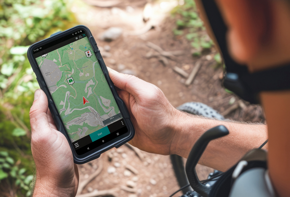
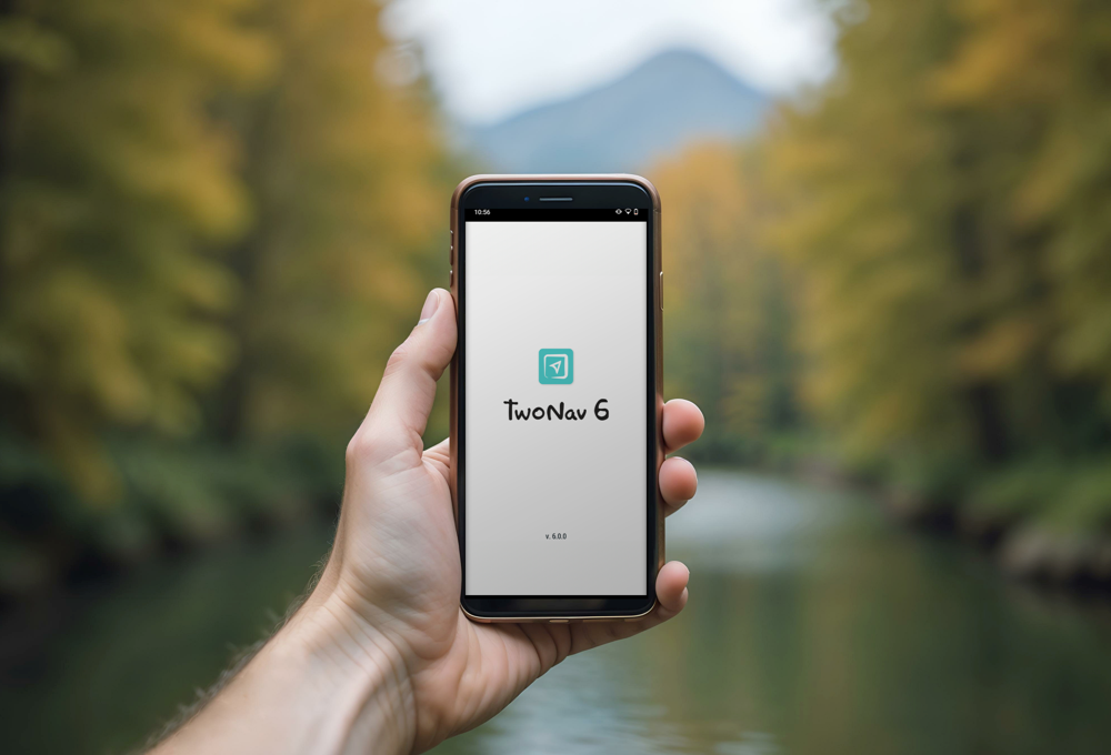
Simple, intuitive, and safe route navigation
Everything you need to explore your surroundings with complete accuracy can be found on your smartphone screen with TwoNav. No matter where you are or the type of terrain you face, TwoNav will guide you safely every step of the way – just follow the directions and enjoy the journey worry-free.
TwoNav adapts to your activity style, whether it's hiking, cycling, motorcycling, flying or water sports. Do you enjoy more than one? Create custom profiles and tailor the app to each experience, ensuring optimal navigation every time.

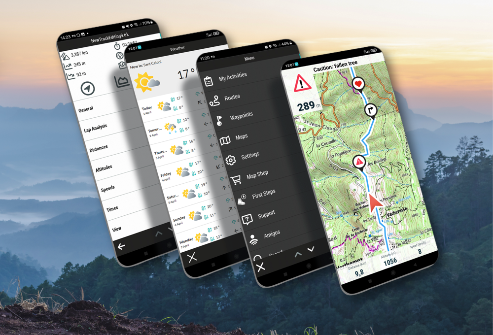
Integrated Route Editor
Create routes point-to-point, freehand, automatically, or modify tracks to suit your needs

Maps Plus
Access highly reliable themed maps for hiking, cycling and other sports

Weather Forecast
Check the weather forecast for several days ahead at your planned exploration spot

Features
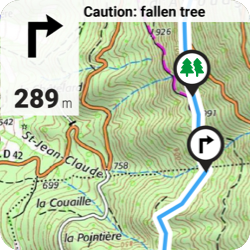
Load your favourite itineraries, preview the routes and go out navigating them knowing the terrain and the most important data of the place you are about to explore. TwoNav will alert you when you stray from the planned route and offer you alternative paths.
-
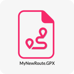
Open routes in multiple formats
Make the most of TwoNav’s broad route format compatibility. No matter the format, TwoNav supports the most common ones including: *.GPX, *.KML, *.KMZ, *.FIT, *.TRK...
-
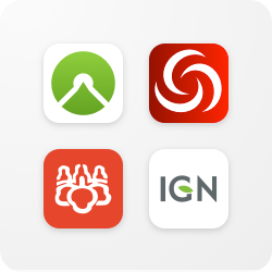
Get the best routes
Connect with the top route providers like Komoot, OpenRunner, UtagawaVTT, IGN Rando and download routes from around the world. Explore new places with reliable routes shared by fellow users like you
-
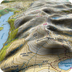
3D View for added realism
Before starting your route, preview the itinerary in a three-dimensional view. Dive in and anticipate the terrain difficulty with a highly realistic simulation
-
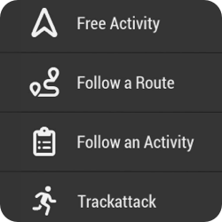
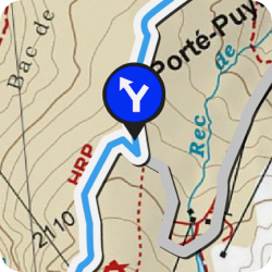
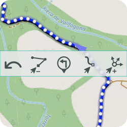
Navigation types
TwoNav offers several navigation types – choose the one that best suits your activity type: free navigation, follow a track, go to specific coordinates, compass navigation...
-
Roadbooks
Forget paper guides – TwoNav will guide you step by step with instructions, photos, and comments along your routes. Enjoy hiking or bikepacking with intuitive and enriched navigation as you progress
-
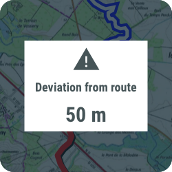
Visual and audible alarms
Get alerts whenever you deviate from the planned route. TwoNav will recalculate your path to bring you back on track. Keep your efforts under control by setting alarms for heart rate, speed, pace...
-
Always have a plan B
Don’t stick to just one plan – navigate routes with variants so you’ll always have alternative paths to choose from. Pick the route that best suits current conditions and avoid improvisation with confidence.
-
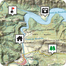
Mark waypoints along your route
Mark the most important points of your route by creating a collection of waypoints along the way. Select the exact spot and add a name, icon, and description (shelter, lake, fountain, village)
-
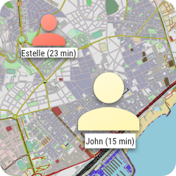
Broadcast your location live
With Amigos™, you and your group can share your locations in real-time, wherever you are, viewable from both TwoNav and Land. This exclusive TwoNav feature ensures both your safety and peace of mind for your loved ones

Open routes in multiple formats
Make the most of TwoNav’s broad route format compatibility. No matter the format, TwoNav supports the most common ones including: *.GPX, *.KML, *.KMZ, *.FIT, *.TRK...

Get the best routes
Connect with the top route providers like Komoot, OpenRunner, UtagawaVTT, IGN Rando and download routes from around the world. Explore new places with reliable routes shared by fellow users like you

3D View for added realism
Before starting your route, preview the itinerary in a three-dimensional view. Dive in and anticipate the terrain difficulty with a highly realistic simulation

Navigation types
TwoNav offers several navigation types – choose the one that best suits your activity type: free navigation, follow a track, go to specific coordinates, compass navigation...

Roadbooks
Forget paper guides – TwoNav will guide you step by step with instructions, photos, and comments along your routes. Enjoy hiking or bikepacking with intuitive and enriched navigation as you progress

Visual and audible alarms
Get alerts whenever you deviate from the planned route. TwoNav will recalculate your path to bring you back on track. Keep your efforts under control by setting alarms for heart rate, speed, pace...

Always have a plan B
Don’t stick to just one plan – navigate routes with variants so you’ll always have alternative paths to choose from. Pick the route that best suits current conditions and avoid improvisation with confidence.

Mark waypoints along your route
Mark the most important points of your route by creating a collection of waypoints along the way. Select the exact spot and add a name, icon, and description (shelter, lake, fountain, village)

Broadcast your location live
With Amigos™, you and your group can share your locations in real-time, wherever you are, viewable from both TwoNav and Land. This exclusive TwoNav feature ensures both your safety and peace of mind for your loved ones

Tools
Take full advantage of TwoNav to control your itineraries and the most important data of your routes. With TwoNav, you can create your own tracks and analyse them using valuable insights.
-
 New
New
Create routes automatically
Just mark the starting and ending points and the FastTrack function will generate your route and add waypoints at key manoeuvres. You can also create routes point to point through the places you want to visit.
-
 New
New
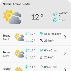
Weather forecast
Before heading out, plan ahead and check the weather forecast. Get detailed forecasts for any location several days in advance, including rain, cloud cover, wind and more.
-
Training
Use TwoNav to train by time or distance... or go a step further by competing against yourself with TrackAttack™. Try to beat a previous effort — TwoNav will show whether you are improving or need to pick up the pace.
-
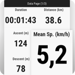
+200 real-time data points
Track over 200 real-time stats such as altitude, distance, ascent, power, speed and more. Customise TwoNav's data pages to show the information most relevant to your activity.
-
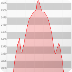
Graphs
TwoNav includes an advanced graphing system that provides a clear visualisation of metrics like altitude, speed and heart rate.
-
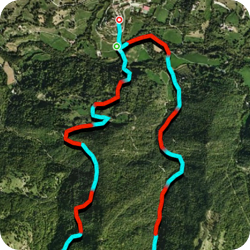
Segments
Split your track into custom segments to better analyse your performance. Fine-tune your navigation and optimise your effort to reach your goals more efficiently.
 New
New
Create routes automatically
Just mark the starting and ending points and the FastTrack function will generate your route and add waypoints at key manoeuvres. You can also create routes point to point through the places you want to visit.
 New
New
Weather forecast
Before heading out, plan ahead and check the weather forecast. Get detailed forecasts for any location several days in advance, including rain, cloud cover, wind and more.

Training tools
Use TwoNav to train by time or distance... or go a step further by competing against yourself with TrackAttack™. Try to beat a previous effort — TwoNav will show whether you are improving or need to pick up the pace.

+200 real-time data points
Track over 200 real-time stats such as altitude, distance, ascent, power, speed and more. Customise TwoNav's data pages to show the information most relevant to your activity.

Graphs
TwoNav includes an advanced graphing system that provides a clear visualisation of metrics like altitude, speed and heart rate.

Segments
Split your track into custom segments to better analyse your performance. Fine-tune your navigation and optimise your effort to reach your goals more efficiently.

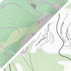
Maps
When navigating a route, it's important to understand the advantages and disadvantages of each type of map so you can choose the most appropriate one for each situation. TwoNav allows you to use the following types:
-
Online maps
These maps are not stored on your smartphone — they are accessed via the internet. They typically offer worldwide coverage and are updated frequently with the latest information.
-
Offline maps
Use these maps anytime without an internet connection, as they are saved in the internal memory of your device. Usually focused on regional or national coverage, they ensure you stay safe even when offline.
-
 New
New
Maps Plus
Highly reliable maps tailored to specific sports. Each version highlights the most relevant information for a particular sport (cycling, hiking, etc.). Subscription required and internet access needed.

Online maps
These maps are not stored on your smartphone — they are accessed via the internet. They typically offer worldwide coverage and are updated frequently with the latest information.

Offline maps
Use these maps anytime without an internet connection, as they are saved in the internal memory of your device. Usually focused on regional or national coverage, they ensure you stay safe even when offline.
 New
New
Maps Plus
Highly reliable maps tailored to specific sports. Each version highlights the most relevant information for a particular sport (cycling, hiking, etc.). Subscription required and internet access needed.
Work with high-quality maps
Explore your surroundings in maximum detail. Load multiple maps simultaneously and view them at the same time or switch between them. Move the map freely and smoothly to find the best perspective. Discover new points of interest near your current position. Use the map that best suits each situation:
-
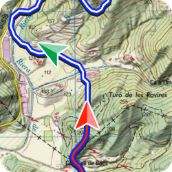
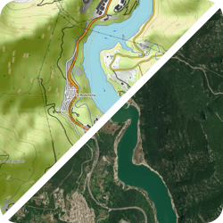
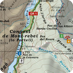
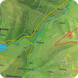
Topographic
Designed for the mountains, these show the terrain relief you are about to explore. Contour lines give you an idea of the area's difficulty. You'll find trails, shortcuts, national parks, lakes, and more.
-
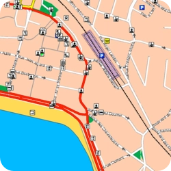
Road
Usually urban and interurban maps used for driving or motorcycling. They include all kinds of road information: street names, directions, key points of interest such as hospitals, hotels, restaurants, petrol stations...
-
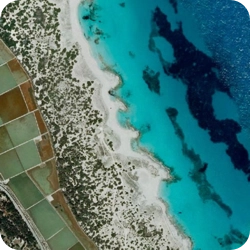
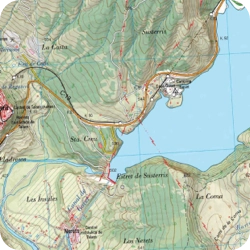
Orthophotos
Aerial photographs taken by satellite, allowing you to quickly identify landscape elements wherever you are—whether in the mountains or the city: fields, lakes, shelters, buildings, roads...
-
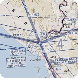
Aeronautical
If you engage in aerial activities like paragliding, microlight flying, gliding or ballooning, use this type of map to easily find landing strips, restricted flight zones...
-
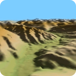
3D Reliefs
The three-dimensional view lets you simulate the environment of your adventure with a highly realistic rendering of your destination. Move freely through the 3D simulation to comfortably assess the difficulty of your route.
-
Add more map types
If you have your own maps or want to use others (nautical, aeronautical...), copy them to your smartphone’s internal memory or microSD card and open them in TwoNav to view and start working with them.

Topographic
Designed for the mountains, these show the terrain relief you are about to explore. Contour lines give you an idea of the area's difficulty. You'll find trails, shortcuts, national parks, lakes, and more.

Road
Usually urban and interurban maps used for driving or motorcycling. They include all kinds of road information: street names, directions, key points of interest such as hospitals, hotels, restaurants, petrol stations...

Orthophotos
Aerial photographs taken by satellite, allowing you to quickly identify landscape elements wherever you are—whether in the mountains or the city: fields, lakes, shelters, buildings, roads...

Aeronautical
If you engage in aerial activities like paragliding, microlight flying, gliding or ballooning, use this type of map to easily find landing strips, restricted flight zones...

3D Reliefs
The three-dimensional view lets you simulate the environment of your adventure with a highly realistic rendering of your destination. Move freely through the 3D simulation to comfortably assess the difficulty of your route.

Add more map types
If you have your own maps or want to use others (nautical, aeronautical...), copy them to your smartphone’s internal memory or microSD card and open them in TwoNav to view and start working with them.

Maps included in TwoNav 6
TwoNav 6: Discover all the new features
TwoNav 6 introduces numerous improvements to ensure your safety on any terrain you explore. Enjoy easier, more intuitive navigation with new exclusive features: a redesigned interface, automatic route generation, weather forecasts, updated maps, and many other enhancements. Discover them all!
See all the new features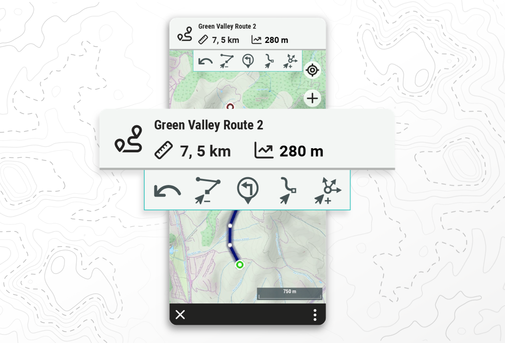
New integrated route editor
The new TwoNav route editor lets you create routes quickly, whether point-to-point, freehand drawing, or letting TwoNav generate the route automatically for you. You can also use existing routes to modify their paths as needed: extend or shorten the itineraries as much as you like.
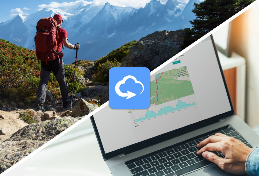
Connect everything with TwoNav Cloud
The TwoNav ecosystem centralises your files in the TwoNav Cloud so they are available to you anytime, anywhere—on your computer, GPS device, or mobile phone. Plus, GO™ lets you connect with services like Strava™, Komoot™, DropBox™, or Google Drive™ to make the most of them all.
No matter your level, TwoNav is for you
No matter your experience level or the sport you practise, TwoNav adapts to all types of users, whether you're an occasional hiker or an expert mountaineer. Configure data pages with the information you need, change your track's appearance, customise your waypoint collections, or organise your routes and activities by folders. If you practise multiple sports, configure a profile for each sport so TwoNav will adapt its setup and calculations accordingly.
TRY IT FREE NOW
What better way to discover TwoNav than to try all its features yourself


This software uses libraries from the FFmpeg project under LGPLv2.1.
DISCOVER THE TWONAV SUBSCRIPTION PLANS
Experience more for less. Try PRO for free for 30 days
Try PRO features for 30 days for free. Once over, FREE plan will be activated. No credit card required
Free
$0- Record your activities in the TwoNav App
- Analyze a route or activity on your smartphone (TwoNav App) or on your computer (Land) with basic data
- Use the free online maps and your purchased maps
- 30 MB of space in TwoNav Cloud to store your files
Try PRO features for 30 days for free.
No credit card required
- No advertising
- Open multiple routes simultaneously
- Create routes in the TwoNav App with simple tools
- Navigate your routes with distance, time, and ascent data to your destination.
- Receive alerts when deviating from the route
- Find the way back at any time
- Automatically save online maps for faster future access (cache 100MB)
- 250 MB of storage in TwoNav Cloud to save your files
Cancel anytime
Automatically renewed until cancelled
- Create routes in Land or the TwoNav App with advanced tools (AutoRoute, FastTrack, Roadbooks...)
- Download OSM maps worldwide to calculate routes and work offline
- Plus Maps online, fast, and reliable
- Weather forecast for any location
- Stunning 3D views of your maps and routes
- Switch maps quickly from the map window
- Open personal maps in *.RMAP, *.MPV, *.MPVF formats
- Work with different collections of waypoints
- Advanced settings (data fields, alarms, profiles...)
- Friends™ service to locate and communicate with other users
- 1 GB of storage in TwoNav Cloud to save your files
Cancel anytime
Automatically renewed until cancelled
- * Open maps from other sources in *.ECW, *.MBTiles, *.TIFF(COG) format in Land and App
- Weather forecast maps for temperature, cloud cover, and precipitation
- Create vector maps to mark trails, points of interest, and exclusion zones
- Create hypermaps by combining multiple maps into one for easy access
- Import maps in advanced formats *.SHP, *.SID, *.TIFF...
- Generate offline maps for your GPS/App TwoNav from online maps
- Create your own maps from images
- Connect GPS from other brands and get your current position in Land
- 5 GB of storage on TwoNav Cloud to save your files
* Maps compatible with Land and App. The rest of the advanced map functions are available only in Land.
Cancel anytime
Automatically renewed until cancelled


 Secure Payment
 Free shipping on orders over €60 (EU)
 Hassle-free returns